Spitsbergen 2012 - From Wawel Hill to Mountain Wawel
Leg: 12.05
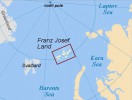
Cruise rout: Longyearbyen - Franz Jozef Land - Longyearbyen
Svalbard – FJL Itinerary
Day 1
Longyearbyen, the administrative capital of the Spitsbergen archipelago of which West Spitsbergen is the largest island. Before embarking there is an opportunity to stroll around this former mining town, whose parish church and Polar Museum are well worth visiting. Preparing the Boat for a trip, loading food and other provisions into the boat.
Day 2
One of the Northern Exploration Company’s (NEC) largest installations was established at Calypsostranda, just north-west of Recherchefjorden. Coal was extracted here in the early 1900s, but the enterprise never attained full production. Today, Calypsobyen offers an exciting landing that gives visitors a glimpse of the era of Neo-Industrialism, when all opportunities for profit were tried out.
Day 3
We sail Ahlstrandhalvøya at the mouth of Van Keulenfjorden and will land by Zodiac there. Here piles of Beluga skeletons (the Beluga is a small white whale), the remains of 19th century slaughter, are yet another reminder of the consequences of thoughtless exploitation. Belugas were not hunted to the edge of extinction and may still be seen locally. Indeed, there is a good chance that we will come across a pod. Cruising into Recherchefjorden during the afternoon we can explore an area of tundra at the head of the fjord where many Reindeer feed.
Day 4/5
Sailing quietly the side fjords of the spectacular Hornsund area of southern Spitsbergen, enjoying the scenery of towering mountain peaks. Hornsundtind rises to 1,431m while Bautaen shows why early Dutch explorers gave the name ‘Spitsbergen’ - pointed mountains - to the island. There are also 14 magnificent glaciers in the area and very good chances of encounters with seals and Polar Bears. Landing on Zodiacs and visiting Polish PAN arctic station and cross walking with Polish researches looking for tundra flora. Sailing to Diskobukta.
Day 6
We will sail south to Diskobukta on the west side of Edgeøya. If the sea condition will be good we will go on Zodiac cruise through the shallow bay, we can land on a beach littered with whale bones and tree trunks, which have drifted here from Siberia. We can also climb to the rim of a narrow gully which is inhabited by thousands of Kitttiwakes, together with Black Guillemots and piratical Glaucous Gulls. During the breeding season, the base of the cliffs is patrolled by Arctic Foxes and Polar Bears, especially females with young cubs, searching for young birds that have fallen from the nesting ledges. From there we will sail to Freemansundet. In Freemansundet we plan to land at Sundneset on the island of Barentsøya to visit an old trapper's hut and then take a brisk walk across the tundra in search of Spitsbergen Reindeer and Barnacle Geese. Barentsøya covers an area of 1288km². At the top of the island is Barentsjøkulen, a glacier with several names inspired by Henrik Ibsen’s play, Peer Gynt: Solveigdomen (Solveig Dome) and Peer Gyntslottet (Peer Gynt Castle) stretch as tall as 650 m.a.s.l. The glacier covers much of the eastern part of the island with its area of 558 km². It has four branches that reach into the sea – Besselbreen in the north-east, Willybreen in the east, Freemanbreen and Duckwitzbreen in the west of the island.
Day 7/8/9 Sailing to FJL
Day 10
One of the most interesting place to visit in Franz Josef Archipelago is Alexandra Island with ca. 1050 km², is the fourth biggest island of the archipelago, situated in its Northwest. Its larger southwest part (Moon Ice Cap) and a minor part in the East (Kropotkina Ice Cap) are covered almost completely by two ice caps, out of which only a few capes, promontories and coastal rock faces protrude. Among these capes: Cape Mary Harmsworth as the westernmost point, Cape Lofley and Cape Ludlow in the south and Cape George Thomas as the easternmost promontory. On the northern shore, the rocks of Cape Nimrod are most markant. The north of Alexandra Land is quite different to the heavily glaciated south: a relatively flat, hilly tundra region with numerous ponds and ice-age moraine ridges - one of the largest ice-free zones of the whole archipelago. The highest point of the island is the top of Moon Ice Cap. During the 1950s, the northernmost Russian base on land, Nagurskoe, was established nearby the site of the former German station. In addition to its military purposes, Nagurskoe served also as a scientific base. The airstrip of Nagurskoe is the only still operational one in all of Franz-Josef-Land. Furthermore, there is a small weather station as part of the base. Since 2006, Nagurskoe was modernized with some new buildings for the about 2 dozen members of the Russian border units based there, plus occasional guests. Even an orthodox chapel was erected. In late April 2010, prime minister Vladimir Putin visited Nagurskoe. Furthermore, there have been ideas of installing a tourism hotel for the archipelago here, suitably located near the airbase both for arrival and departure and for flights within the archipelago. We will visit the base is named after the Polish-Russian arctic aviation pioneer Jan Nagorski (Ivan Nagurski) (1888-1976) who was the first to use a fixed-wing aircraft in the arctic in 1914.
Day 11 Prince George Island
Prince George Island is both the biggest (ca. 2820 km²) and the longest (115 km) in Franz-Josef-Land. As typical for most parts of the archipelago, it consists of extensive complexes of tabular mountains, which are mostly covered under ice caps (elevations up to 415 m above sea level), while a few steep rock capes and edges peek out of the ice masses along the coastlines, including also some minor ice-free lowland stretches on and below the cliffs. Due to the larger variety of icefree terrain types, also the range of bird species on this large island is bigger, including probably all regular breeder species of the archipelago: Primarily Alle alle, Uria lomvi, Rissa tridactyla, Cepphus grylle, Fulmarus glacialis and Larus hyperboreus nesting in steep cliffs or slopes, while the other species are found more spread over the icefree areas in considerably smaller numbers.
Day 12 Hooker Island
Hooker Island is situated inside the south-western part of the archipelago, on the east side of the British Channel. Its maximal extension is about 35 km. The most interesting part of Hooker Island is the Calm (Tikhaya) Bay in the Northwest of the island, which can boast with two major attractions: Rubini Rock and the former Tikhaya Station. On Hooker Island, fossile bones of a Plesiosaurus were found, witnessing a much warmer period long ago in Earth´s history. Of newer date, about 1300 years old, are reindeer antlers found here, witnessing a former reindeer population during the more favourable early mediaeval climatic optimum period, when also the vikings started their expansion. Today, after the grim little iceage, there is no reindeer population left on the archipelago.
Day 13 Champ Island, stone spheres (geodes) - Franz-Joseph-Land
Champ Island lays in the interior of Franz-Josef-Land Archipels and ranks among the medium-sized islands with a maximal diameter of ca. 27 km and an area of ca. 374 km². The interior of the island is mountainous, with flat tabular tops, and is heavily glaciated. Main attraction on Champ are the geodes in attractive landscape surroundings at Cape Triest. Originally, the place fascinated by stone balls in all sizes, including thousands down to just a few centimetres. Unfortunately, maybe two dozen land calls of ships during the years since 1991 have been enough to loot Cape Triest of most of the smaller spheres, which disappeared in tourist pockets and most likely most of them have been thrown away since in the home places of the travellers or will end that way, when their heirs don´t have any sense for them. Only the bigger sizes, too big to be taken as souvenirs, are still there, including the famous really big ones. Of course, new geodes will erode free, but not as fast. Therefore, visitors should abstain from the temptation of picking geodes as souvenirs to preserve the unique character of the place. In the lower areas under the geodes field, there is also an interesting flora including not only flowers but also mosses and less attention-attracting plants, and east of it, some skuas are breeding on the ground - plus the bird colonies up in the rock face of the cape. To avoid damages, landings should focus onto the mound and bed of the little stream coming down from the geodes zone as an access route and should avoid entering the vegetation and birdlife zones east of the stream. Due to highly differing and changing ice conditions both out in Markham and Yermak Sound, and right in front of the beach, landings are not always possible by boat.
Day 14/15/16 Sailing to Nordaustlandet Icland
Day 17
Today we will sail into Hinlopen Strait, home to Bearded Seals, Ringed Seals, Polar Bears, and Ivory Gulls. We’ll navigate the ice floes of Lomfjordshalvøya in our zodiacs and explore the bird cliffs of Alkefjellet with thousands of Brünnich’s guillemots. On the east side of Hinlopenstrait, we’ll attempt a landing at Augustabukta on Nordaustlandet, home to Reindeer, Pink-footed Geese, breeding Ivory Gulls, and Walruses. Near Torrelneset, we will explore the polar desert of Nordaustlandet, next to the world’s third largest ice cap, which meets the sea nearby. We will walk along beautiful coastline covered in smooth rocks, sculpted by the surf over thousands of years. We may encounter walruses along the way.
Day 18
Near the mouth of Liefdefjorden, we will go ashore for a walk on the tundra island of Andøya. Many common eiders and pink-footed geese nest here, and the more rare king eider may also be seen. Sailing into Liefdefjorden, we will cruise near the face of the impressive Monaco Glacier. The waters of the glacier front are a favourite feeding spot for thousands of kittiwakes and occasionally polar bears are seen on the glacier.
Day 19
Heading south along the west coast, we arrive by morning in Krossfjorden, where we go on the Zodiacs for a cruise along the sculpted front of the 14th of July Glacier. On the green slopes near the glacier, a colourful variety of flowers bloom, while large numbers of Kittiwakes and Brünnich’s Guillemots nest on the nearby cliffs. There is also a good chance of spotting Arctic Foxes, who patrol the base of the cliffs in case a chick falls from its nest, and Bearded Seals, who cruise this fjord. In the afternoon we sail to Ny Ålesund, the world’s most northerly settlement. Once a mining village - served by the world’s most northerly railway, which can still be seen - Ny Ålesund is now a research centre. Close to the village is a breeding ground for Barnacle Geese, Pink-footed Geese and Arctic Terns. Visitors interested in the history of Arctic exploration will want to walk to the anchoring mast used by Amundsen and Nobile in the airship Norge in 1926 and Nobile in the airship Italia in 1928 before their flights to the North Pole.
Day 20
Return to Longyearbyen and disembark for the transfer to the airport and the flight to Oslo and home.
N.B.
The chances that we can complete a full Spitsbergen Circumnavigation together with FJL exploring (based on tours operators experiences from 1992 until 2009) are about, 55% in the second half of July, 90% in the first half of August. In case we cannot complete a full circumnavigation we will mostly resort to a programme in Southeast Spitsbergen/FJL.
The extracts of the text become from www.franz-josef-land.info
Back to expedition
NEWS
- Wielka Pętla post scriptum
2012.08.15
Dalsze powiązania z magiczną liczbą 4 - Nashachata II on Great Svalbard Loop
2012.08.12
Nashachata II on Great Svalbard Loop 20.07-12.08.2012 Short summary - Polar Bear
2012.08.03
Edgoya Island, Tjuvfjorden and a Polar Bear